Jonesport
Wood Co.
|
Real Estate - Hulls Cove
Land for Sale
|
For Captain Tinkham's Emporium in Searsport Listing Click Here
Hulls Cove, Maine {Bordering Acadia National Park}
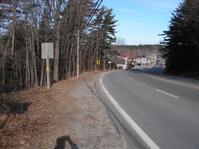
US Route 3 road frontage starts from here and goes to just before the
first building on the left.
All the photos March 2006
This land is listed by the Lynam Agency in Bar Harbor.
The land is located in Hulls Cove, a village that is considered
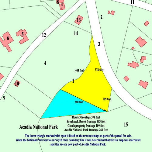
part of Bar Harbor, Maine. It is about +/- 1.75 acres. There
are 260 feet of frontage on the Acadia National Park boundary, 403 feet
of water frontage on Breakneck Brook, 378 feet of frontage on Route 3,
and the possible building envelope is 11,552 square feet. The MEDOT
has indicated that a driveway may be put into the property well away from
the Breakneck Brook. Both town water, sewer and electric are available
at the street.
This piece of land is available in the following price
ranges:
1) $185,000.00
2) To a land preservation organization - prevent further
development of the land or donate to Acadia National Park (call).
The owner's personal preference is that the land not be
developed and be incorporated into the National Park. There is no interest
among local land trusts and park preservation groups to incorporate this
land into the park, and all inquiries have involved commercial development
of the property. The 11,552 square foot buildable portion of the land available
is large enough for a small commercial establishment, but could be a rather
unsightly intrusion for visitors entering the park in Hulls Cove. No significant
opposition exists for commerical development, but the land with it's slope
towards Breakneck Stream would lend itself to a creatively designed post
& beam residence/workshop that would be a compromise between a commercial
development and no development at all. Comments and suggestions about the
disposition of this piece of real estate are solicited.
Parcel is marked in yellow on the map below.
Please send inquiries by fax to 207-288-2725 or contact
Mr. Brack directly by phone ~ 207-288-5126 during the day E.S.T.
E~mail inquiries may be sent to: curator@davistownmuseum.org
(Please put "Land for Sale" in your subject heading.)
Prospective buyers please note: the property is located
directly adjacent to Acadia National Park land; due to the sensitive location
of this parcel, covenants on the use of the property should be discussed
with the current owner. It is hoped that any future use of the property
will be compatible with the adjacent park, its millieu, the traditional
architecture of the village, and the year round community of working artists
and writers living nearby.
 ---
---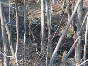
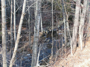
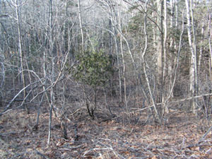
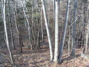
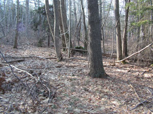
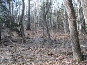
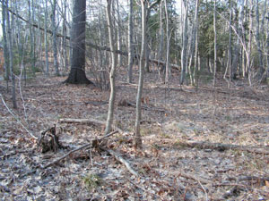
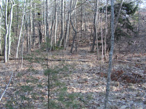
Views of Breakneck Brook, the west boundary.
 ---
---
 ---
---
 ---
---
Follow this link
to see the official Bar Habor Assessor's map. Lot 223-10 is in the
upper right area of the map. It shows the required setback from the
Breakneck Brook in red. The Acadia National Park boundary is also
in red. Please note that as indicated on the map above, the assessor's
map does not show the boundary correctly. Read the Project
Memo and Project Memo second page
(a .pdf format file) to learn more about this boundary error.
You may also read a letter
from the Assessing office (.pdf format) estimating the available building
envelope.
Background history
The piece of land offered for sale is one of three parcels
of the former Brewer Estate, 19th century shipbuilders living in Hulls
Cove, Maine, hence the name of the cove, Hulls for ship's hull. The
land was purchased by Harold G. Brack and Suzanne Nash (d. 1999) in 1986
and is still owned by Harold G. Brack. In 1990, the Geronimo Sculpture
Gardens were established on parcel 4 (see map) on the opposite side of
Breakneck Brook (1 on map). In 1999, the Sculpture Gardens became
part of the Davistown Museum and are now called the Davistown Museum Hulls
Cove Sculpture Gardens. About 50 sculptures and art assemblages are
displayed on +/- two acres. Parcel 4 will never be developed and
will always be part of a non-profit.
The head of the tide for Breakneck Brook and Hulls Cove,
located on Frenchman's Bay is approximately 50 feet on the other side of
the Route 3 bridge going over the brook. The brook crosses under
the road at 2 on the map and the head of the tide is just a little further
down the stream. Numerous coasting vessels were built by the Brewers
and other shipbuilders just below the head of the tide and along the Hulls
Cove waterfront, which runs adjacent to Route 3 just north of the Post
Office (7) and General Store (8). One of the photographs shows the
view looking north on Route 3 towards the General Store (Exxon sign).
In the opposite direction from the photo of the General Store lies the
entrance to the visitor's center of Acadia National Park.
Building 5 is a circa 1840s farmhouse, formerly the Brewer
Estate, and now the Brack - Brown residence. The main office of the
Davistown Museum and its Hulls Cove painting gallery and reference library
are located within this residence. Building 6 is the Hulls Cove Tool
Barn and greenhouses, and is the shipping and receiving station for all
the antique and used hand tools sold at the Tool Barn, the Liberty Tool
Co. and Captain Tinkham's Emporium (see photo tour on website). Building
10 is the home and pottery and painting studios of Rocky Mann and Carol
Shutt.
Number 9 represents the Breakneck Road (12) entrance to
Acadia National Park. The park is only open to foot and bicycle traffic
on this road; the road was closed to motor vehicles, ATVs and snowmachines
a number of years ago. The Breakneck Road has a long history of several
thousand years of use. In the 19th century it was the main road from
Hulls Cove to Northeast Harbor. Three quarters of a mile into the
park the road crosses the Breakneck Brook and runs up a hill. Numerous
wagon accidents occurred on this hill, hence the name "break neck brook";
also hence the name Breakneck Valley on old postcards. A number of
rusticators built estates in the area near the Breakneck hill; when the
Rockerfellers deeded their land to the National Park, all vestiges of these
estates were removed and the area for the next 10 miles from the entrance
to the park (9) appears to be wilderness even though it was once farmed,
logged and had several residences. Two miles down the Breakneck Road,
past Breakneck Pond, lies Eagle Lake and almost 200 miles of hiking and
biking trails. Seal Harbor Beach is about a 10 mile hike from Hulls
Cove, all of which lies within the National Park.
Hulls Cove lies on Frenchmans Bay, so named because of
extensive French fur trading efforts in the area, which began sometime
after 1535 (Cartier's voyage down the St. Lawrence). The Breakneck
Brook was the most accessible and sheltered year-round fresh water supply
on Frenchmans Bay for French traders, Champlain and other explorers, English
man-o-war, privateers and 19th century rusticators, all of who landed at
Hulls Cove to get fresh water. In the era before the great pandemic
(1617 - 1619) Hulls Cove was a summer fur trading station. Most fur
traders at this point in time were French rather than English. Numerous
French trading posts lie to the east of Hulls Cove and are noted in Hale's
History
of Bar Harbor. Hulls Cove was a convenient trading station not
only due to the availability of year-round fresh water, but also because
for thousands of years indigenous Abenaki trappers, fishermen and families
had journeyed down the Union River or the Taunton River to land at Hulls
Cove and hike the short distance to the rich shellfish resources at Asticou
(Northeast Harbor), and at the head of Somes Sound. The Hulls Cove
archaeological site (14) is a proposed location for future archaeological
investigations and is located on parcel 4 in the section closest to Route
3, next to the old Higgins Garage, now a summer art gallery and flower
shop. A service road runs off of Route 3 and into the National Park
Visitor's Center parking lot; 15 notes the location of the park service
garage, which is visible from the back corner of the lot for sale.
In August, 1604, Samuel de Champlain explored Frenchmans
Bay as far as the narrows opposite the Trenton shoreline. Returning
he ran his shallop up on a rock, probably Googin's Ledge near Hadley's
Point. Controversy exists as to the two locations where he landed
to repair his shallop spending several nights in a cove under the mountains.
Some contend this was Cromwell's Harbor on the east side of Bar Harbor,
but this was not as active a fur trading location as Hulls Cove, which
was much more sheltered and the more likely location for Champlain's visit.
Champlain continued his journey to the mouth of the Kennebec River before
returning to spend a brutal winter at St. Croix Island. For more
information about Mawooshen, the Native American confederacy of which Hulls
Cove was once a part, see the Davistown Museum publication Norumbega
Reconsidered. For a detailed description of the history of
Mount Desert Island see Hale's The Story of Bar Harbor and Samuel
Eliot Morison's The Story of Mount Desert Island. In 1693,
two French soldiers, Armand de Vignon and Francois Albert, who had betrayed
Pierre Le Moyne de Iberville's planned attack on Pemaquid, were tomahawked
in front of 120 Native American men, women and children at Hulls Cove under
the supervision of Baron de St. Castine and de Iberville who then "slid
out of Frenchmans Bay past Ironbound Island". The last French settler
in the area was Madame de Gregoires, who having received as a friend of
Lafayette a grant of land for half of Mount Desert Island from the General
Court of the Commonwealth of Massachusetts (1786) then began selling off
her lands in the late 18th century to the English settlers whose descendents
now occupy Mount Desert Island.
The land offered for sale along the edge of the Breakneck
Brook lies adjacent to the probable location of the summer encampments
of the Native Americans who traded with the French at this location in
Frenchmans Bay for almost 150 years and is very close to the location of
the historic tomahawking of de Vignon and Albert, as well as to the location
of Champlain's likely campsite along the Breakneck Brook in 1604.